AgroSOS Project
Management information
Project description
The development of agriculture has contributed to satisfying the nutritional needs of a growing world population. While in the third world, with deaths due to malnutrition, it continues to be a priority to satisfy the most basic needs, in the most developed countries, agricultural management is required to go further, since in addition to ensuring the adequate satisfaction of resources, it must preserve the good ecological state of the ecosystems.
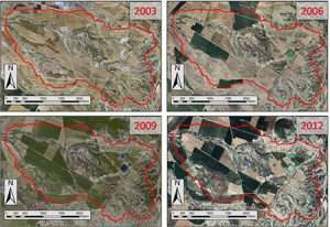
The monitoring carried out since 2003 through previous projects of the national research plan (AGL2005-07161-C05-01/AGR, CGL2009-13410-C02, CGL2012-32395, and CGL2015-66016-R) make the Lerma basin ( 750 ha, Zaragoza) in an excellent natural laboratory to continue studying the evolution of the environmental impact of the transformation into irrigation.
Once the before, during, and after the transformation into irrigation and implementation of management alternatives have been successfully analyzed, one of the objectives of the requested project is to evaluate said agronomic measures and verify to what extent the use of water can be maximized. agrochemicals and minimize the environmental impact with special emphasis on how to increase the treatment effectiveness of artificial wetlands. For this, it is intended to take advantage of all the historical investment in equipment and knowledge by extending the environmental monitoring of the Lerma basin, carried out by the main nucleus of the requesting research team, twenty years from now (2003-2023).
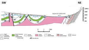
In parallel, and once hydrologically monitored with the previous project (CGL2015-66016-R) the Gallocanta Lagoon (Directed Nature Reserve and RAMSAR wetland, Teruel-Zaragoza), this new project aims to analyze the trends and vulnerability to contamination by nitrates of this important natural enclave, studying management alternatives and adaptation to climate change through its hydrogeological modeling.
Targets
Achieving sustainable integrated agrosystems continues to be a research challenge for society. Maximizing the use of water and agrochemicals in the context of climate change with a decrease in water resources and pollution induced by agriculture is together with the establishment of recovery and improvement measures, the ultimate objective of this project.
- Analyze the evolution of the environmental impact due to the transformation into irrigation in the long term (2003-2023).
- Analyze the effects of the alternatives in irrigation and fertilization management implemented in previous projects.
- Analyze the treatment capacity of wetlands under different strategies.
- Establish an environmental diagnosis of the fight against hail.
- Mapping the vulnerability to nitrate contamination of the Gallocanta aquifers.
- Study management strategies for the Gallocanta agrosystem through its hydrogeological modeling.
Activities
It is based on valuable information from the continuous monitoring carried out since 2003 in the Lerma basin (Bardenas II, Zaragoza). Additionally, a GIS for the Gallocanta basin is intended to be completed and updated through this activity.
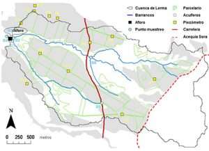
Through this activity, it is intended to continue the analysis of the evolution of the chemical quality of water resources as well as the geochemical modelling of the Lerma basin.
The environmental evaluation of irrigation will be carried out with the EMR application (http://www.jcausape.es/emr.html), obtaining the trend of irrigation quality indices and contamination induced by irrigation.
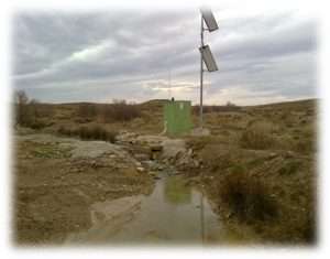
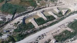
The control of the purification efficiency with continuous monitoring of the entry and exit of water from an artificial wetland will be completed with isotopic studies confirming the water's purification.
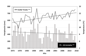
The creation of daily series is expected from at least the 50s of the 20th century to the present. Temperature and rainfall trends and their relationship with cycles of filling-emptying of the lagoon, migratory customs of the cranes, etc. will be analyzed.
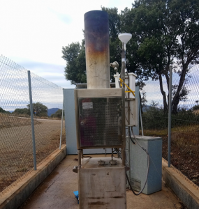
Anti-hail systems used for decades in the Gallocanta area may involve the contamination of soils and sediments in which AgI accumulates once it falls to the ground through precipitation in the form of hail or rain. A network of atmospheric deposition sensors will be installed at several points with different but comparable environmental characteristics.
Through this activity, it is intended to carry out the geochemical characterization of the environment of the Gallocanta lagoon. Soil and sediment sampling campaigns will be carried out at different scales to verify possible contamination by the AgI emitted by the anti-hail generators.
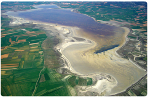
An analysis of the evolution and magnitude of the trends in the concentration of nitrates in the water mass from 1980 to the present will be carried out, including a detailed spatiotemporal analysis. Mapping the danger and vulnerability of the Gallocanta aquifer will be prepared to allow the development of better plans for the vulnerable area.
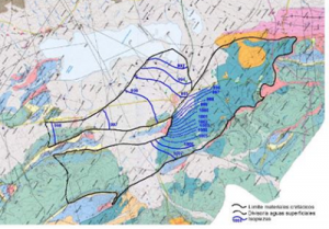
A three-dimensional geological model will be built that covers the entire Gallocanta Groundwater Mass – 090,087 and most of the surface basin of the Gallocanta lagoon, later to develop a coupled model of surface and groundwater flows.
