Skip to content
Logo IGME
  • The IGME
    • Presentation
    • IGME History
    • Organization Chart
    • Geological Service
    • Headquarters
    • Territorial Units
    • Associated Units
    • Phone Book
    • Annual Reports
    • Transparency
    • Gender Equality
    • International Relations and National Alliances
    • Employment
  • Research
    • Presentation
    • Geological Hazards and Climate Change
    • Water and Global Change
    • Geological Resources for the Ecological Transition
    • Geology and Subsoil
    • Projects
    • Publications
    • Transfer
  • Services
    • Presentation
    • Service Catalog
    • Geominer Museum
    • Lithotheque
    • Labs
    • National Geological Service
    • Aerial Works Service
  • Data and Maps
    • Presentation
    • Geoscientific Websites
    • Document Information System
    • Data Catalog
    • Geological and Thematic Cartography
    • Cartographic Viewer
    • Map Services
    • Metadata
    • Thematic Applications
  • Museum
    • Museum Presentation
    • Museum History
    • Collections
    • Conservation and restoration
    • Repository of polar geological samples
    • Educational Zone and Didactic Activities
    • Piece of the Month
    • Visit us
    • Contact us
    • Museum Regulations
    • Our visitors think
  • Infraestructure
    • Library
    • Lithotheque
    • Geominer Museum
    • Documentation Centre
    • Laboratories
    • Fardes River Valley Paleontological Station
  • Outreach and Communication
    • Presentation
    • What do you want to know about Geology and Mining?
    • Multimedia Material
      • Informative IGME Videos
      • Image Bank and Photographic Archive
      • Dissemination Material
      • IGME Pets
    • Geoheritage
    • Fardes River Valley Paleontological Station
    • Geological Guides and other Informative Publications
    • Historical Geological Events
    • News Archive
    • Exhibitions
    • IGME Events Calendar
    • Computer Applications
  • English
    • Español
Intranet

Archives: Fotografía IGME

Logo of the Extreme Geological Events and Heritage research group

Leer más »

San Cocó rock avalanche (Mallorca)

Leer más »

Gorg Blau rock avalanche (Mallorca, Spain)

Leer más »

Valle del rey (La Gomera,Canary Islands)

Leer más »

Landslide in Jesus del Valle (Granada)

Leer más »

Landslide (Ibiza)

Leer más »
Deslizamiento en la Serra de Tramuntana de Mallorca

Landslide in the Serra de Tramuntana mountain range in Mallorca

Leer más »

Logo GI-RESCLIM

Leer más »

Logo GI_CARTO

Geological & geomorfological mapping, 4D geology of orogens and basins Group

Leer más »
Valor del agua en las zonas deserticas o subdeserticas de la provincia de Almería

Survey Retamares, Tabernas (Almería)

Groundwater: Engine of the Almeria economy

Leer más »
Gráfico de la evolución piezométrica en la MASb Mancha Occidental II

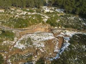
Piezometric Evolution GraphImage

Graph of the piezometric evolution in Mancha Occidental II groundwater body

Leer más »

Piezometry map

Piezometry map of the MASb Western Mancha II in October 2022

Leer más »
Page1 Page2 Page3 Page4 Page5
IGUALDAD IGME
Logo Portal de Transparencia
Logo Plan de Recuperación, Transformación y Resiliencia
#ThisIsTheRealSpain
Datos y Mapas
Linkedin Youtube Instagram Facebook X-twitter Pinterest Wordpress
Logo fachada de la sede principal del IGME en Ríos Rosas

INSTITUTO GEOLÓGICO Y MINERO DE ESPAÑA

Ríos Rosas 23, 28003 Madrid (España)

Teléfono +34 913 495 700

Logo CSIC
Logo IGME

© 2024 Instituto Geológico y Minero de España

  • Mapa web
  • Accesibilidad
  • Condiciones de uso
  • Mapa web
  • Accesibilidad
  • Condiciones de uso
Scroll to top