CONTROLMINES project
Management information
Title: Control geodésico y geotécnico de instalaciones de residuos mineros mediante técnicas integradas de monitorización y modelización
Code: PID2022-138197OB-I00 financiado por MCIN/AEI/10.13039/501100011033/FEDER, UE
Initial date: 1 de September de 2023
Ending date: 1 de September de 2027
Funding: 112500 €
E-mail: jose.fernandez@igme.es
Project description
The CONTROLMINES project focuses on the predictive maintenance of mining waste facilities through numerical modeling coupled with continuous monitoring.
The objective of the CONTROLMINES project is to provide competent authorities and society in general with new methodologies and tools applicable to the real-time monitoring of the stability of mining waste facilities, such as tailings dams and waste dumps, both at regional and local scale. The project includes three main innovative components:
- 4D geo-mechanical modeling and continuous real-time monitoring. New geo-mechanical simulation programs and advanced real-time monitoring techniques will be applied.
- Integration of data into an online software platform. A prototype application will be developed for geodetic-geotechnical control and early warning.
- Validation and application to case studies: The methodology will be tested on different types of waste facilities.
The main goal of modeling is to provide a tool to understand how these geo-structures behave. If the proposed model is capable of reproducing the past and present behavior of such structures, it may also be used to predict their future behavior.
Targets
The CONTROLMINES project will generate knowledge in three main disciplines: (i) numerical modeling of mining structures, (ii) monitoring of these structures using remote techniques, and (iii) designing early warning systems for their sustainable and safe management.
Regarding modeling, while the Material Point Method (MPM) has been developed by several international research groups in recent years, the multiphase (solid-fluid-air) and multipoint version for simulating hydro-mechanical coupling in large deformations is still relatively unexplored. Furthermore, there are currently few constitutive models capable of accurately reproducing liquefaction phenomena. The CONTROLMINES project will develop new numerical MPM models (using the proprietary GeHoMadrid program) and constitutive models (based on the Generalized Plasticity theory with a state parameter) that will allow more realistic simulation of liquefaction phenomena. These new models will improve predictions of the future behavior of mining waste facilities and deepen our understanding of the mechanisms that cause their failure.
Activities
Specific objective 1: Geomechanical modelling of mining structures
Tarea 1.1
Fine-tuning the GeHoMadrid-MPM program for regional scale
A new 3D version of the GeHoMadrid-MPM program to identify different failure mechanisms at the valley (or regional) scale within the same computational mesh is proposed.
The GeHoMadrid finite element program allows for numerical simulation of static and dynamic hydro-mechanical coupling in 3D for geomaterials under small deformations. The technique of shear strength reduction (SSR), combined with a robust numerical implementation of the Mohr-Coulomb failure criterion in 3D, efficiently calculates safety factors (FS) and 3D failure mechanisms. This technique has been successfully tested at the valley scale to identify the critical slope (with the lowest safety factor) in the studied area. However, this approach does not allow for the identification of other slopes or areas within the same computational mesh that may have a higher safety factor. In this context, a new 3D version of the GeHoMadrid program is proposed, which integrates the Material Point Method (MPM) to address this limitation. The MPM method, based on dual discretization (using material points and a traditional finite element mesh in the background), enables the calculation of geomaterial behavior under large deformations. This new GeHoMadrid-MPM version will provide hazard maps for landslides, identifying areas with varying safety factors.
Specific objective 1: Geomechanical modelling of mining structures
Tarea 1.2
Fine-tuning the GeHoMadrid-MPM program for local scale
Additionally, the GeHoMadrid-MPM program will be adapted for simulating liquefaction phenomena, both static (flow-induced) and dynamic (during earthquakes).
The same program will be used for the local study of mining waste facilities, with special emphasis on simulating liquefaction phenomena, both static (due to flow) and dynamic (during earthquakes). To this end, the GeHoMadrid-MPM program will be adapted to simulate the multiphase coupling (solid-fluid-gas) of materials using a multipoint approximation of the MPM algorithm (where each material point represents a single phase). While the MPM technique also allows for studying flow propagation in case of failure, determining trajectories and propagation velocities (essential characteristics for assessing the associated risk), this multipoint approach has not yet been extensively investigated in specialized literature. Therefore, the possibility of developing new constitutive equations capable of realistically reproducing soil liquefaction will be explored. These equations will be based on the Generalized Plasticity models with state parameters already developed by the research team, applicable to both saturated and partially saturated materials.
Specific objective 2: Monitoring of mining structures. Geodetic monitoring: definition of thresholds for early warning.
Tarea 2.1
Generation of remote data through satellite radar interferometry (InSAR)
Satellite radar interferometry (InSAR) techniques will be applied for monitoring mining structures at both regional and local scales with millimeter precision.
Freely-accessible surface deformation data provided by the European Copernicus program, exploiting C-band SAR radar images from the Sentinel-1 satellite, will be used. On one hand, for historical analysis, the European Ground Motion Service (EGMS) will be utilized. On the other hand, for real-time monitoring, images will be downloaded from the public platform ASF (https://search.asf.alaska.edu/#/). These images are of the Single Look Complex-Interferometric Wide swath (SLC-IW) type, with a resolution of 4 meters in the east-west direction and 14 meters in the north-south direction, and with a minimum temporal sampling of 6 days. The use of other satellite images, such as X-band SAR images from the Spanish Paz satellite (or the German TerraSAR-X and Italian Cosmo-SkyMed satellites), will be investigated. Image processing will be carried out using various advanced differential synthetic aperture radar interferometry (A-DInSAR) tools.
Specific objective 2: Monitoring of mining structures. Geodetic monitoring: definition of thresholds for early warning.
Tarea 2.2
Generation of remote data through UAV-based digital photogrammetry (SfM)
UAV-based digital photogrammetry (SfM) techniques will be applied for monitoring mining structures at both regional and local scales.
The acquisition of optical images will be carried out using Unmanned Aerial Vehicles (UAVs) available in the Aerial Works Service (STA) of the CN IGME-CSIC. Three-dimensional point clouds (3DPCs) with RGB color information, as well as very high-resolution digital elevation models (DEMs) and orthoimages, will be obtained through digital photogrammetry (structure from motion, SfM) using commercial software solutions. The use of a UAV-based LIDAR, which will be acquired by the CN IGME-CSIC in the near future, is also planned. The temporal evolution of deformations using these techniques will be evaluated by comparing 3DPCs, digital elevation models, and orthoimages (generated at different dates) using various geospatial data analysis tools.
Specific objective 2: Monitoring of mining structures. Geodetic monitoring: definition of thresholds for early warning.
Tarea 2.3
Generation of real-time in-situ data
Conventional monitoring techniques such as GNSS or inclinometers will be applied, as well as interstitial pressure measurement techniques using piezometers.
The acquisition of pointwise in-situ deformation measurements will be carried out using traditional monitoring techniques such as GNSS or inclinometers. Additionally, piezometer networks will be used to obtain measurements of interstitial pressure. As an example, at Minas Riotinto in Huelva, an active mine operated by Atalaya Mining, the company is working on transitioning all classical geodetic and geotechnical control data to a new digital system for automated real-time geodetic monitoring (project MINERVA #smartgeocontrol). The digital transition of instrumentation optimizes and improves traditional analog readings by automating processes, transmitting data via wireless networks, and centralizing all information on a single platform called GeoMoS-Now - GeoMonitoring Hub (Leica Geosystems).
Specific objective 2: Monitoring of mining structures. Geodetic monitoring: definition of thresholds for early warning.
Tarea 2.4
Data fusion. Geodetic control: defining thresholds for early warning
Algorithms to automatically generate alarms based on the obtained InSAR data may be created.
For regional-scale geodetic control, algorithms may be created to automatically generate, from the obtained InSAR data, early warnings when movements are detected or when significant changes occur in the deformation trends of structures. As an example, analyzing velocity time series using the inverse velocity method provides indications of the moment of failure (tertiary creep) in case of detected instability. For local-scale geodetic control, monitoring data collected through various monitoring techniques will allow validation of the measured deformations in structures. Algorithms may be developed to automatically generate alarms when (i) deviations exist between data obtained from different monitoring techniques (e.g., remote monitoring vs. in-situ monitoring), or when (ii) significant changes occur in the deformation trends of structures (inverse velocity method).
Specific Objective 3: Integration of modelling and monitoring of mining structures. Geotechnical monitoring: definition of thresholds for early warning
Tarea 3.1
Monitoring of environmental conditions. Definition of scenarios
Data on environmental variables (such as rainfall intensity, temperature, etc.) will be collected, and combinations of actions for different scenarios (Normal, Accidental, and Extreme) will be defined.
For the stress-strain analysis of structures, it is necessary to collect environmental conditions such as rainfall intensity, temperature, etc. To calculate safety margins associated with serviceability limit states (SLS) and ultimate limit states (ULS) of structures, we will define combinations of actions for Normal, Accidental, and Extreme scenarios. As an example, for the Extreme Scenario, hydrogeological conditions will take into account exceptional rainfall events with a 500-year return period, and possible updates related to Climate Change will be studied. For seismic conditions, we will use seismic accelerations according to the current Seismic-Resistant Construction Standard for pseudo-static approximations, along with representative synthetic accelerograms (with possible ad-hoc seismotectonic studies) for dynamic calculations.
Specific Objective 3: Integration of modelling and monitoring of mining structures. Geotechnical monitoring: definition of thresholds for early warning
Tarea 3.2
Geotechnical control: defining thresholds for early warning
Algorithms to generate real-time alarms when there are deviations between measured data and calculated results (such as deformation, interstitial pressure, etc.) may be created.
The parameters of geo-mechanical models will be adopted based on the construction project (if it exists) and available literature. These parameters may be calibrated using results from laboratory and in-situ tests or from the monitoring history record. Special emphasis will be given to calibrating permeabilities (both saturated and unsaturated), a parameter that influences the fluid interstitial flow network (and consequently the stability of structures). For local-scale geotechnical control, algorithms may be created to generate real-time alarms when deviations occur between measured data and calculated results. These deviations may arise when the assumptions of the structural design do not align with observed reality. Based on deformation data/results, Serviceability Limit States may be defined, providing early alerts for maintenance. Additionally, using interstitial pressure data/results, real-time Safety Factors associated with the actual state of structures will be calculated.
Specific Objective 3: Integration of modelling and monitoring of mining structures. Geotechnical monitoring: definition of thresholds for early warning
Tarea 3.3
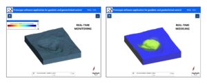
Development of a prototype software application for geodetic and geotechnical control and early warning
A software application will be developed to integrate the collected monitoring data (from satellite and UAV, and in-situ) with the generated geo-mechanical modeling data.
The GeHoMadrid finite element program, developed by the research team, will be integrated with a post-processing program such as GiD (commercial) or Paraview (open-source) into a dedicated software platform. This platform will also collect real-time monitoring data to implement the proposed geodetic and geotechnical control algorithms. The application, which may be web-based, will be developed in collaboration with the GIS Area of CN IGME-CSIC and aims to be used by administrations and companies responsible for safety control in mining waste facilities. The platform will therefore be easy-to-use and have a user-friendly graphical interface.
Specific Objective 4: Application to case studies
Tarea 4.1
Geodetic and geotechnical control of abandoned mining sites in the Cartagena-La Unión region (Murcia)
The proposed methodology will be tested at a regional scale in the Sierra Minera de Cartagena-La Unión (Murcia).
For regional analysis, the case study proposed is the abandoned mining area in the Cartagena-La Unión region (Murcia), on which the research team has worked in recent years. In this area, there is a collection of abandoned mining sites, waste dumps and tailings dams, that have been severely deteriorated by processes of water and wind erosion. These facilities are being restored as they are a source of contamination for the Mar Menor. This case study is of special interest to the Subdirectorate General for Circular Economy of the General Directorate for Environmental Quality and Assessment of the MITERD.
Specific Objective 4: Application to case studies
Tarea 4.2
Geodetic and geotechnical control of the waste dumps from the Feixolín and Fonfría mines (León)
The proposed methodology will be tested at a local scale in the reclaimed waste dumps from the Feixolín and Fonfría mines (León).
For local analysis, the case study proposed is the reclaimed mining area of the Feixolín and Fonfría coal mines (León), associated with two mega waste dumps. The research team has conducted geodetic monitoring of these sites over the past three years. This case study is of special interest to the Secretaría General de Energía y Minas of the Consejería de Economía y Hacienda of the Junta de Castilla y León.
Specific Objective 4: Application to case studies
Tarea 4.3
Geodetic and geotechnical control of the tailings dams from Riotinto Mines (Huelva)
The proposed methodology for real-time analysis will be tested at a local scale in the tailings dams from Riotinto Mines (Huelva).
For real-time local analysis, the mining area of the tailings dams from Riotinto Mines (Huelva), operated by the company Atalaya Riotinto Minera, S.L.U., is proposed as a case study. In this area, an important project update for the dam expansion over the next 10 years is currently being evaluated (with its approval in the process of authorization). This case study is of special interest to the Secretaría General de Industria y Minas of the Consejería de Política Industrial y Energía of the Junta de Andalucía.
Specific Objective 5: Technology transfer and dissemination of results
Tarea 5.1
Presentation of results to competent authorities and companies, publication of results in scientific journals, dissemination of results, and patent study
The results will be presented to interested authorities and companies, published in scientific journals, and promoted through various digital media channels, and a patent proposal will be considered.
At the end of the project, a mini-symposium is planned at the national level to present the project results to the authorities and companies responsible for safety control of mining waste facilities. Additionally, the project results will be published in journals related to the mining, geological, and civil engineering sectors, and will be promoted through various digital media channels (such as this website or social media profiles). Finally, if the prototype proposed for geodetic, geotechnical, and early warning control of mining waste facilities shows positive results and is validated with the proposed case studies, and if there is interest from government and private sector mining companies, a patent proposal will be considered in collaboration with the Unidad de Transferencia del Conocimiento y Tecnologías of ICP-CSIC.


Collaborators
No data was found
Involved groups
Publications
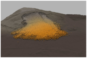
Image gallery
Controlmines project figure
Related video gallery
No hay videos en el proyecto

Collaborating institutions
No hay entidades colaboradoras.